Worldbuilding Intensive (part 2)
I have lots of feelings about maps

Hello from week 2 of the Worldbuilding Intensive workshop with DMG! Last week, we talked about the ways we organize worldbuilding information. We made lists of objects, organized and categorized in ways that reflect how people think within our worlds. This week, we dove into a very specific method for organizing information: maps.
Colloquially, we tend to think of maps as giving us an objective understanding of the space around us. In other words: when we want to know about the place we’re in, we often look at a map, and we don’t think a lot about the values embedded in maps - we trust that they will give us an accurate understanding of space.

We often bring this way of thinking into our worldbuilding. When we want to get a general sense of the space in which the world takes place, we draw a map - and we tend to default to top-down maps that emphasize accurate geography.
The problem is that just like other media, maps are produced by people, and the way they convey information is influenced by the values and power structures of the societies in which those people live. The notion that these top-down geographical maps can objectively represent space reflects the values of our society. And as I’ve talked about before, objectivity and total understanding are deeply colonial values. In fact, mapping was a key part of colonialism: processes of colonization often began with mapping, which was seen as a form of capturing territory in and of itself.
This isn’t to say that you’re secretly a colonialist if you wanted to draw a geographically-accurate map of your world! Having grown up seeing maps in this way, of course we would reach for this mapping strategy without thinking. But when we recreate these same kinds of maps, in a sense we are reproducing the same values and ways of thinking that have come to dominate our world. And if worldbuilding is about imagining alternatives, then we should start thinking of alternative ways to map out our worlds, too. So what does that look like? Luckily, we can draw from our own world here, too: there are a wealth of real-life maps that show us alternative ways of mapping and understanding space.
Topological Maps
Alternative mapping doesn’t have to be an explicitly political project. In fact, many of us see other kinds of maps every day:

This is a map of the Hong Kong MTR system. As you can probably guess, the geography of Hong Kong is not made up of simple rounded squares; this is not a geographically accurate map. But topological maps like this one help us understand how different places relate to each other — which places are considered central or peripheral, how long it might take to get from one place to another, and so on — without resorting to geographical accuracy.
Here is a more overtly political topological map:

This map depicts the topology of national borders, but removes any information about a country’s shape and size. Just like the MTR map, this map gives us a sense of how places relate to each other: we can get a different sense of the kinds of political complexities that might emerge for countries that border a lot of other countries (China), or for countries that border only one or two (Canada).
These are just a couple of examples. If you had to radically simplify or remove any geographical data from your map, what information would you convey to your readers? How would you help them understand the space of your world differently?
Psychogeography
The practice of mapping itself has a long and storied tradition of political activism, too. One strain of this is psychogeography, or the practice of studying and mapping places based on your individual emotional associations with them. Psychogeography is often weird and playful: practitioners go on dérives, which basically means they wander around the city and taking note of how it makes you feel. Here’s a really cool map of Paris by the philosopher Guy Debord:

And here’s a more recent and very charming map of the Ohio Wesleyan University campus, created by a geography professor there, in collaboration with a group of middle school students. This map documents smells, textures and sounds on a walk throughout campus:

These maps also give us a very different sense of the spaces they depict. They might not help us navigate these spaces in the same way that Google Maps does, but they give us a much better sense of what it feels like to be there — and what that means for their designs and political inner workings.
Mapping time
Most maps claim to show us a location at a specific point in time, but you can also use maps to depict the passage of time itself. Using maps to express time can help us think differently about space: it helps us understand space as mutable For example, this map by Harold Fisk depicts the movements and flow changes of the Mississippi river over the course of over a century:
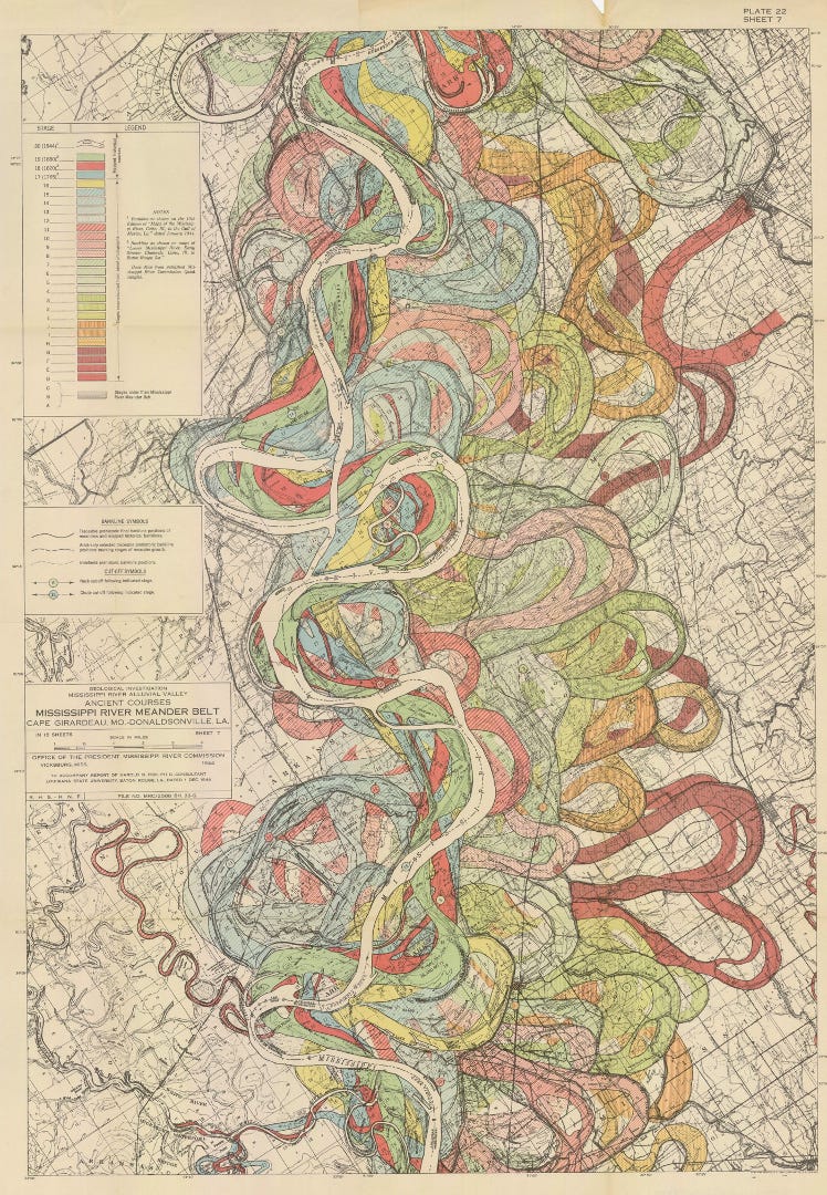
Mapping time can help us understand the history of our location better, but it can also help us think about spaces differently: as mutable, inconsistent, and shifting over time.
Mapping power and resistance
As I mentioned before, mapmaking has long been part of colonialism, with countries using maps as ways to demonstrate their power over places. Maps were often made into games for people to play in order to demonstrate and practice their knowledge of the colonies, like in this 1645 French game Le Jeu du Monde, which depicts all the countries in the world revolving around France:

Light content warning for racist imagery: maps also became blueprints for state propaganda, racial caricatures, and political comics, like this 19th century map of Europe that depicts Russia as a scary octopus:

But just as maps can be used to depict power relations, political ideologies and threats, you can also use maps to shed new light on local political issues — and to galvanize resistance. This map by the Counter-Cartographies Collective expresses political and social issues at Queen Mary University in London, making interesting use of a combination of geographical maps, hand-drawn pictorial maps, and text:

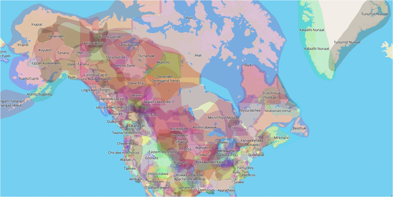
Finally, we can use the familiar contours of geographical maps to reconfigure how we think about the spaces we live in. The Native Land project, for example, aims to create a comprehensive map of Indigenous nations and languages. It uses a geographically-accurate map of the world as a backdrop, but rather than depicting hard boundaries and borders, it overlays nations on top of each other, demonstrating an alternative way of thinking about land and ownership:
Conclusion + Other Resources
If you’re interested in seeing more radical and interesting maps, here are a few websites you might check out:
The Counter-cartographies Collective, which partners with artists and community organizations to make maps depicting collective struggles and social issues;
Guerrilla Cartography, a group that produces regular “atlases” made up of maps that all cover specific political themes from a variety of perspectives;
Radical Cartography, a website maintained by Bill Rankin, an associate professor at Yale studying the history of cartography. He logs and discusses maps that are of interest to him and that imagine space in an interesting way.
You might also search for a few keywords: “protest maps,” “guerrilla cartography,” “counter-cartography,” “radical cartography,” “Indigenous cartography” and “psychogeography” have all gotten me to some interesting places, on both Google and Wikipedia.
Exercises
I’m sure that by now you’ve predicted the exercise for this week, but here you are anyways:
The challenge: Draw a map of a specific location within your world.
The catch: the map’s primary purpose must be to convey something other than geographical accuracy. Geographical accuracy can influence your map, or form a part of it (as with the map of Queen Mary University, or the Octopus map of Europe), as long as this is not the primary purpose of the map.
Ask:
Who drew this map? Was it one person, or multiple people?
What was this map’s purpose?
Why organize it the way they did?
Are maps normally organized this way in your world? Are there other ways of making maps? If so, who prefers this type of map and why?
That’s all for this week! See you all next week for the third instalment of the Worldbuilding Intensive, and my own favourite: characters!